Panama Mountains & Highlands
Panama’s mountains and highlands offer cool weather year-round and have become a popular retirement destination for people from around the world, especially North Americans and Europeans.
The Cordillera Central forms a broken backbone from Costa Rica in the west, gradually descending toward Panama City. Farther east toward Colombia, the range is known as the Serranía de Tabasará or Cordillera de San Blas. Although Panama is a land bridge between North and South America, the country actually runs west to east in the shape of a recumbent “S”.
The Panama Canal was constructed at one of the lowest points to carry ships across the continental divide. The Cordillera Central divides Panama into the coastal lowlands of the Pacific and those of the Caribbean and strongly influences the country’s weather patterns. Generally, there is more rain on the Caribbean side, where the mountains block the warm, moist trade winds. Most of the population lives on the Pacific side, southwest of Panama City.
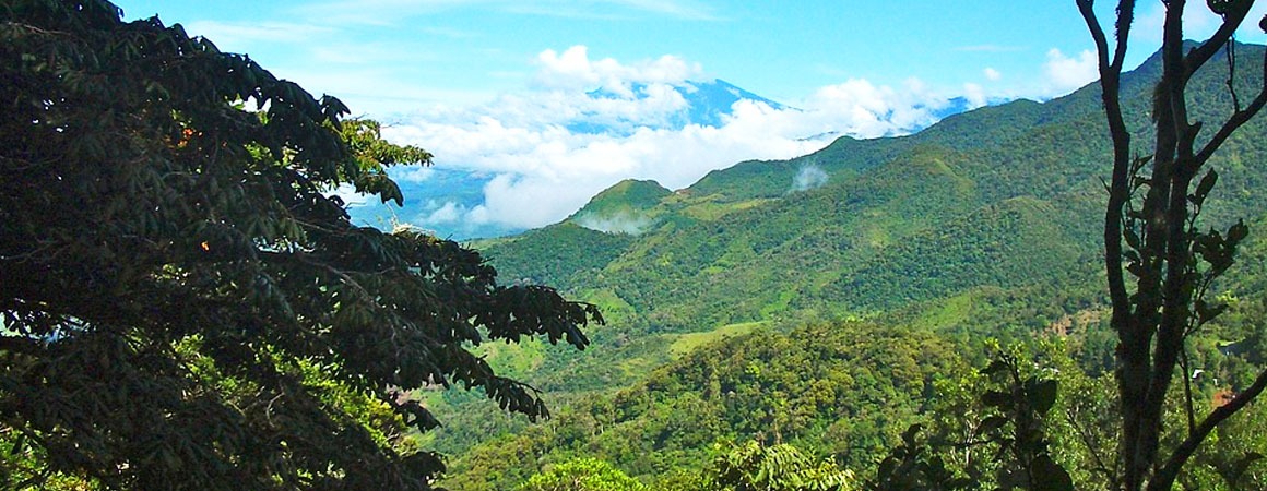
Altitude affects temperature, so higher elevations offer a cool, pleasant respite from the tropical lowlands. Panama’s highlands are rapidly becoming top spots for adventure travel—whitewater rafting, kayaking, hiking, and rock climbing. A pristine environment and few crowds make Panama a standout destination. These are the only mountains between northern Central America and the Colombian Andes, creating many endemic bird species. In the Chiriquí Highlands you’ll find two of Panama’s finest national parks.
In the Coclé Mountains, several second-home and retirement projects are being developed for those seeking a quieter lifestyle without losing modern comforts—think golf, stables, and tennis. Coclé also offers beaches and broad plains where salt, rice, and sugar are produced and cattle are raised, plus a rich handicraft tradition. All this is about 90 minutes from central Panama City.
Panama – Highest Mountains
| # | Name | Elevation | Latitude/Longitude |
|---|---|---|---|
| 1 | Volcán Barú, Chiriquí | 3,474 m | 8.809, -82.541 |
| 2 | Cerro Fábrega, Bocas del Toro | 3,335 m | 9.117, -82.867 |
| 3 | Cerro Pirre, Darién | 1,459 m | 7.927, -77.702 |
| 4 | Cerro Bruja, Colón | 979 m | 9.478, -79.565 |
| 5 | Cerro Santo Domingo, Colón | 792 m | 9.449, -79.663 |
| 6 | Carreto Yala, Darién | 769 m | 8.694, -77.621 |
| 7 | Cerro San Francisco, Panamá | 558 m | 9.356, -79.508 |
| 8 | Cerro Cisneros, Colón | 425 m | 9.302, -79.596 |
| 9 | Cerro Pan de Azúcar, Colón | 419 m | 9.498, -79.660 |
| 10 | Cerro Los Cañones, Panamá | 415 m | 8.924, -80.036 |
Barú Volcano National Park
Volcán Barú National Park, in Chiriquí Province, covers 14,325 hectares (35,000 acres) and protects a unique mix of highland rainforest species and striking volcanic geology from ancient eruptions. The park is home to the resplendent quetzal—one of the few places where sightings are likely with a good guide. A strenuous hike reaches the highest crater rim, where, on a clear morning, both the Pacific and Caribbean are visible.
From Panama City, fly about one hour or drive six hours to David, then continue 30 minutes by car to Boquete (about 40 km / 25 miles). From Boquete you can access the main park entrance, summit route, and multiple trails.
La Amistad International Park
Shared by Panama and Costa Rica, La Amistad spans foothills and mountains of the Cordillera de Talamanca. About half of its 407,000 hectares lie in Panama. This is Central America’s highest and wildest non-volcanic range, formed by uplift and later sculpted by heavy rains and ancient glaciers—evident in cirque lakes and steep valleys near Chirripó National Park.
Park entrances are found at Cerro Punta and Guadalupe on the Volcán Barú side, and at Wetzo near Changuinola. A UNESCO World Heritage site, La Amistad shelters numerous plant, bird, and animal species across seven of twelve classified life zones.
For more on Panama’s national parks, click here.
Boquete and the Chiriquí Highlands
Boquete sits on the Caldera River in Panama’s green mountain highlands, about 60 km (37 mi) from the Costa Rica border. At roughly 1,200 m (3,900 ft) above sea level, it enjoys a cool climate, beautiful scenery, and rich natural surroundings—popular with locals and international visitors alike.
The town has a lively arts scene. The Boquete Jazz & Blues Festival, founded in 2007, is the country’s second largest after the Panama City Jazz Festival. Nearby Volcán Barú (3,475 m) is Panama’s highest point; hikers enjoy routes like the Sendero de los Quetzales between Boquete, Cerro Punta, and Volcán. The Caldera River shapes the town’s landscape.
Boquete also has a strong expat presence—over 3,000 permanent foreign residents from more than 30 countries—fueling hospitality growth from boutique lodgings to resorts. The area’s spring-like weather, oranges, and gourmet coffee are renowned; cloud forest rivers and waterfalls frame coffee-clad hillsides. A tradition of welcoming newcomers dates back to early settlers in 1911.
Interest has spurred planning initiatives for environmental and urban development and expanded investment to nearby Caldera, Palmira, and Potrerillos.
We can help you identify options—visit our Real Estate Marketplace.
Volcán, Bambito, Cerro Punta & Guadalupe
On the western slopes of Volcán Barú, these small communities feature rolling pastures, cattle and horse farms, and high-slope fields of vegetables and flowers. Cerro Punta—famous for strawberries—means “little pointed hill.” Guadalupe is known for its orchid sanctuary. Bambito hosts a four-star hotel and a trout farm.
Close to park entrances for Barú and La Amistad, the area is ideal for ecotourism and is drawing investors following Boquete’s lead.
To view properties across Panama, visit our Real Estate Marketplace.
Getting There (Chiriquí Highlands)
Fly about one hour from Panama City to David; Boquete is a 45-minute drive from the airport (rental cars available). Volcán, Cerro Punta, and Guadalupe are a bit farther. By road, it’s roughly six hours from Panama City, weather and conditions permitting.
El Valle
El Valle de Antón, in Coclé Province, is a popular weekend retreat about two hours from Panama City via good roads (turn off the Inter-American Highway). The town sits in the broad caldera of the inactive El Valle volcano (~6 km wide). At 600 m elevation, it’s cooler than the lowlands.
El Valle is known for golden frogs, “square” trees, and the La India Dormida ridge silhouette. With cool climate, forests, waterfalls, petroglyphs, and a daily public market (busiest on Sundays), it’s a favorite for locals and tourists. Attractions include Chorro El Macho, Las Mozas, thermal pools, El Níspero Zoo, a serpentarium, and the Aprovaca orchid center. Petroglyphs at La Piedra Pintada lie west of town.
The area also produces onions, radishes, lettuces, and spring onions, and is a growing agrotourism destination, with certified farms across Chiriquí, Coclé, Colón, Herrera, and Los Santos offering rural experiences.
Getting There (El Valle)
El Valle is about two hours from Panama City via the Inter-American Highway. Nearby, Altos del María (10 minutes from El Valle) sits 1,540–3,750 ft above sea level with ocean views and forest footpaths—cooler than the city and about 20 minutes to the beach. Multiple coastal developments between Panama City and Farallón offer additional options. Improved road links make these areas increasingly accessible.
Business Panama Group together with Pardini & Asociados
provides a convenient One Stop Shop offering the services of...


Subscribe to our newsletters
Get news updates about Panama Investments,
Business, Immigration, Real Estate and more...
Doing Business in Panama 2025
An essential reading for the investor or company setting up a business for first time in Panama. Get our guide Doing Business in Panama completely FREE on the link below.
DOWNLOAD IT NOW!